Interactive 3D VR Simulation & Modeling Software
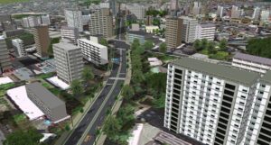
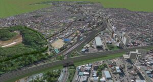
FORUM8’s interactive VR-Design Studio* software is deployed by hundreds of research organisations, urban planners, transportation authorities and vehicle manufacturers across all four continents to create fully immersive, realistic models of the built environment.
●CityGML Data Export
VR Design Studio is used as a platform to create, edit and output city models from VR Design Studio. VR Design Studio can output LOD1-2 building models and LOD1 road and terrain models, etc. When PLATEAU’s CityGML is loaded, the CityGML data can be re-exported with the same information as the CityGML data, so that the original information can be reproduced and output as much as possible except for the parts that have been changed.
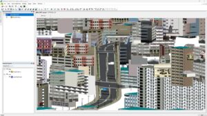
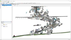
Display CityGML data exported from VR Design Studio on viewer
●Import of Flood Navi Data
The Tsunami Plug-in is now equipped with a function to download inundation data from the Flood Navi system of the Ministry of Land, Infrastructure, Transport and Tourism, enabling visual inundation simulations using the data on UC-win/Road. It is possible to check water level changes over time and visualize gradients to create a realistic representation of the water surface by using the Tsunami Plug-in function.
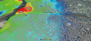
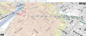
(Left) Simulation on UC-win/Road using Flood Navi data
(Right) Animation on the MLIT’s Flood Navi
●VISSIM linkage
- UC-win/Road Ver.17 can be linked to VISSIM 2023.
- VISSIM TCP linkage
UC-win/Road and VISSIM can be linked even if they are installed on the different PCs. - VISSIM Multi User
When a cluster linkage is established and the master PC is cooperated with a VISSIM, the vehicles operated by the multi-user client are also sent to VISSIM.
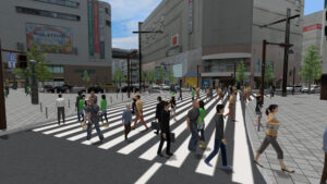
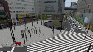
▲Vehicle and pedestrian flow analysis by VISSIM is imported into VR
(The 21st 3D VR Simulation Contest on Cloud Essence Award
“VR Simulation Reproducing Traffic around Hon Atsugi Station” Oriental Consultants Co., LTD.)
●Python Interface (COM API)
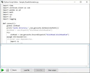
Python API accesses the main functions of UC-win/Road via COM to control such as driving simulator, model and characters, main screen camera, ribbon menu items and buttons, etc.
●Improvement of Road Editing
Useful features have been added for more efficient road modeling.
- Undo/Redo
VR Design Studio can undo up to 10 previous operations, and the Redo function to cancel the previous Undo operation has also been added. - Save and Import Road Alignment
Export/Import and copy/paste functions for road alignments will be available in the Plan View. The road cross section and road surface texture used in the alignment are saved along with the alignment, allowing for accurate reproduction of the road geometry and materials. - Change Road Start/End Point
●LKA
A function to represent this LKA movement has been added. The function calculates the amount of deviation from the correct lane and computes the force applied to the steering wheel and the amount of steering wheel correction according to this deviation and speed. The reaction force on the steering wheel will be reflected in game controllers that support force feedback and will be compatible with various driving simulator hardware that supports torque control. In addition, it is possible to play a pre-set warning sound when the vehicle deviates from its lane. Assuming the linkage between this function and external systems, it can acquire the calculation results of this function in real time, enabling it to be used in the research and development of HMI and traffic safety systems linked to the LKA function.
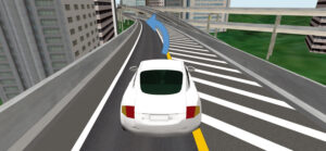
Interactive 3D VR simulation and modeling software VR-Design Studio enables users to dynamically manipulate 3D space, run unlimited drive simulation scenarios, import and edit CAD data, build and texture models, and automatically add roads, tunnels and bridges to create multiple design alternatives in real time, both off and online. The completed models provide users with the ability to visualize and intelligently interact with the virtual world they have created, enabling analysis of the potential environmental impact of the proposed development, including on pedestrian and vehicular traffic flows, to facilitate the widest possible stakeholder collaboration during the planning process.
With an extensive range of industry standard 3rd party plugins available, together with access to external data sources including laser-scanning, Lidar and photo-logs, users can quickly create 3D VR environments and run unlimited scenarios and simulations. Within these environments reproducing all types of environmental effects including weather, light, topology and road-surface conditions to create a highly realistic platform for advanced driver and emergency incident response training.
*(VR Design Studio is also known as UC /Win Road in other regions of the world)
Key Features and Functionality
- Drive simulation
- Urban planning and 3D modeling
- Traffic simulation and analysis
- Unlimited scenario production and way-point setting
- Automatic creation of roads, tunnels bridges etc within 3D environments
- Emergency planning and evacuation simulation
- 4D simulation function
- Free large database of 3D models and environments available – buildings, vehicles, people, street furniture etc.
- The ability to import Point Cloud and Photo-log data seamlessly
- Realistic driving conditions including an off-road driving option
- Advanced driving simulation, ADAS and autonomous driving
- Change and control environmental conditions, time of day, smoke/fire particle and geo-location
- Earthquake and seismic analysis as well as flood/tsunami simulation
- Pedestrian simulation, individually or in crowds
- SDK available for customization
- Extensive range of 3rd party software interfaces available
- Available linkage with multiple hardware platforms
FREE TRIAL
A VR Design Studio Trial version is available for users considering purchasing the software.
Request a Trial Version
