Soil engineering is an essential element in the design of sound and safe foundations for large-scale structures including buildings, bridges,, earth dams and reservoirs. FORUM8’s suite of analytical software includes specialist inhouse developed and 3rd party geo-technical solutions that can be deployed together with Engineer’s Studio or as stand alone products to provide detailed analysis of the ground conditions of major projects.
FORUM8 VG Flow® - 3D Seepage Analysis Software
Saturated/unsaturated seepage analysis program using Finite Element Method (FEM) is based on the analysis solver produced by the Prof. Ugai laboratory (Department of engineering, Gunma university). This product has been developed by customizing VisualFEA as pre and post parts. It provides easy ways to generate two and three dimensional (2D and 3D) complicated shaped geological boundary models, and several functions such as regular meshing, auto-meshing and re-meshing by setting types and dimensions of elements. Stationary and transient analysis can be conducted in 2D vertical, 2D axisymmetric, horizontally 2D and 3D models using several boundary conditions.
-
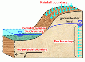
Steady flow and unsteady flow analysis can be performed, and a wide range of boundary conditions are supported so that almost all 2D seepage phenomenon can be modeled.
– Two-dimensional vertical plane flow model
– Axisymmetric flow model
– Two-dimensional horizontal plane flow modelBoundary Types
– Known hydraulic head(:Steady/Unsteady)
– Potential seepage face(:Steady/Unsteady)
– Rainfall(:Steady/Unsteady)
– Flux(:Steady/Unsteady)
– Fluctuating water level(:Unsteady)
– Outflow forbidden(:Unsteady)
– Point source(:Steady/Unsteady)
-
– Allows terrain configuration model creation from a variety of electronic medium and drawing
– Common operating interface with our geotechnical series FEM products
– Anisotropy of water permeability coefficient, terrain inclination
– Direct input via table for unsaturated seepage property
– Support for Japanese main parameter including “River Bank Structure Guideline”
– Obvious output with animated time history for unstable analysis result
XPSWMM Flood Analysis Software
XPSWMM is a holistic 1D/2D modeling package for stormwater and wastewater problems. It helps engineers and watershed managers to simulate hydrology, hydraulics, water quality and surface flooding.
Conduct Advanced Hydrologic and Hydraulic Analysis:
Integrated 1D and 2D capabilities allow you to model interaction between flood waters and drainage systems – giving you the complete picture of water flows for all urban and rural elements.
Flexible Reporting:
Customize output results to provide a full view of what happens, when, and where - giving engineers a complete understanding of risks and system performance.
-
- River and Floodplain management
- Analyse storm-water, sanitary and combined sewer systems
- Conduct scenario analysis
- Build models efficiently
12d Terrain Modeling, Surveying and Civll Engineering Software
12d Model is a powerful terrain modelling, surveying and civil engineering software package.
It allows quick and high quality production in a wide variety of projects.
Using 12d Model's screen menus and fast interactive graphics, the user effortlessly moves through a design.
-
- Road and Highways
- Ports and Dredging
- Land Development
- Airport Infrastructure
- Rail
- Mining Infrastructure
- Drainage, Sewer and Utilities
- Surveying
- Oil and Gas
- Construction
- Rivers, Dams and Hydrology
- Environmental
